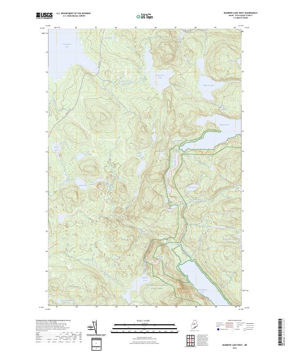
2024 Map of Rainbow Lake West
USGS Topo · Published 2024About this map
The Appalachian National Scenic Trail cuts a winding path through this North Maine Woods landscape, crossing over Rainbow Stream and skirting the southern shore of Rainbow Lake. This terrain is defined by a dense network of interconnected waterways, where the massive Chesuncook Lake in the northwest corner transitions into Chesuncook Stream and Chesuncook Pond. The presence of the Golden Rd underscores the area's ongoing significance to the timber industry, providing a primary transport artery through the remote forests of Piscataquis County.
Find a feature on this map
36 named features on this map. Tap any name to fly to it.
Don’t see what you’re looking for? This feature index may not catch every label — zoom into the map to look around manually.
Map Details
Editions of this 2024 Rainbow Lake West Map
This is the sole edition of this map. No revisions or reprints were ever made.
Other maps of this area

1952 · Jo-Mary Mountain
USGS Topo · 1:62,500

1952 · First Roach Pond
USGS Topo · 1:62,500

1954 · Grant Farm
USGS Topo · 1:62,500

1954 · Harrington Lake
USGS Topo · 1:62,500

1954 · Millinocket
USGS Topo · 1:250,000

1958 · Millinocket
USGS Topo · 1:250,000

1960 · Millinocket
USGS Topo · 1:250,000
1978 · Rainbow Lake West
USGS Topo · 1:24,000
1978 · Caribou Lake South
USGS Topo · 1:24,000
1978 · Wadleigh Mountain
USGS Topo · 1:24,000