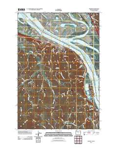
2011 Map of Rainier
USGS Topo · Published 2011About this map
The Columbia River serves as the central artery for this Pacific Northwest borderland, where the industrial hubs of Longview and Kelso overlook a complex network of channels and sloughs. Timber and shipping legacies are evident at the Port of Longview and the expansive Log Pond, while the river's path is marked by shifting features like Cottonwood Island and Slaughters Bar. On the Oregon side, the landscape transitions from the riverfront town of Rainier into the upland drainages of Beaver Creek and Goble Creek. Local history is preserved in scattered cemeteries such as the Knights of Pythias Cemetery and Hudson Cemetery, alongside the rural site of the Fernhill School. The presence of the Rainier Reservoir and the rail activity at Longview Junction illustrate the infrastructure supporting these riverside communities.
Find a feature on this map
127 named features on this map. Tap any name to fly to it.
Don’t see what you’re looking for? This feature index may not catch every label — zoom into the map to look around manually.
Map Details
Editions of this 2011 Rainier Map
This is the sole edition of this map. No revisions or reprints were ever made.
Other maps of this area

1919 · Mayger
USGS Topo · 1:62,500

1921 · Kalama
USGS Topo · 1:62,500

1922 · St. Helens
USGS Topo · 1:62,500

1940 · Vernonia
USGS Topo · 1:62,500

1941 · St Helens
USGS Topo · 1:62,500

1941 · Clatskanie
USGS Topo · 1:62,500

1943 · Vernonia
USGS Topo · 1:62,500

1943 · St Helens
USGS Topo · 1:62,500

1948 · Vancouver
USGS Topo · 1:250,000

1950 · Vancouver
USGS Topo · 1:250,000