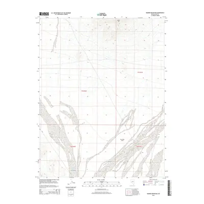
2014 Map of Rainier Mountain
USGS Topo · Published 2014About this map
Big Smoky Valley dominates the southern half of this landscape, where complex alluvial fan patterns illustrate the drainage from the high desert terrain. The arid basin is defined by the ephemeral flow of Long Wash and Idlewild Creek, which originate near the prominent slopes of Rainier Mtn in the north. This 2014 survey documents the remote road network of Nye County, tracing the historical Fremont Route as it parallels the valley floor alongside modern routes like NV-89. Local access points such as San Antone Rd, Peavine Rd, and Seifer Ln intersect the desert flats, providing a detailed record of land management and transportation in this part of the Great Basin.
Find a feature on this map
13 named features on this map. Tap any name to fly to it.
Don’t see what you’re looking for? This feature index may not catch every label — zoom into the map to look around manually.
Map Details
Editions of this 2014 Rainier Mountain Map
This is the sole edition of this map. No revisions or reprints were ever made.
Other maps of this area

1907 · Tonopah
USGS Topo · 1:250,000

1908 · Tonopah
USGS Topo · 1:250,000

1956 · Tonopah
USGS Topo · 1:250,000

1959 · Tonopah
USGS Topo · 1:250,000

1962 · Tonopah
USGS Topo · 1:250,000

1964 · San Antonio Ranch
USGS Topo · 1:62,500
1980 · Cloverdale Ranch
USGS Topo · 1:24,000
1980 · Outlaw Springs SE
USGS Topo · 1:24,000
1980 · Outlaw Springs NE
USGS Topo · 1:24,000

1980 · Secret Basin
USGS Topo · 1:24,000