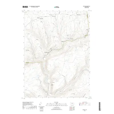
2019 Map of Ralston
USGS Topo · Published 2019About this map
Ralston and Roaring Branch anchor the north-south corridor of Lycoming Creek in this northern Pennsylvania landscape. The terrain is defined by narrow valley settlements and steep ridges like Joe Hill and Laurel Hill, with numerous tributary runs such as Abbott Run and Miners Run cutting through the highlands. Small clusters of homes and family cemeteries are scattered across the plateau, including Ogdensburg and Union Center in the north. The area shows a clear pattern of historical settlement tied to the creek and early transport routes like McIntyre Rd and Roaring Branch Rd. Notable landmarks like Band Rock and Pickenville Mtn overlook the deep valleys, while more remote names like Yellow Dog Run and Sixth Bottom Hollow indicate the region's rugged and specialized local nomenclature. Genealogists can find several small burial grounds such as Stull Cem and the McNett Cem tucked into the hillsides.
Find a feature on this map
69 named features on this map. Tap any name to fly to it.
Don’t see what you’re looking for? This feature index may not catch every label — zoom into the map to look around manually.
Map Details
Editions of this 2019 Ralston Map
This is the sole edition of this map. No revisions or reprints were ever made.
Other maps of this area

1921 · Trout Run
USGS Topo · 1:62,500

1923 · Trout Run
USGS Topo · 1:62,500

1925 · Blossburg
USGS Topo · 1:62,500

1927 · Blossburg
USGS Topo · 1:62,500

1930 · Warrensville
USGS Topo · 1:62,500

1934 · Warrensville
USGS Topo · 1:62,500

1942 · Canton
USGS Topo · 1:62,500

1944 · Blossburg
USGS Topo · 1:62,500

1944 · Trout Run
USGS Topo · 1:62,500

1944 · Canton
USGS Topo · 1:62,500
Featured Places
- South Union, Union Township
- Newelltown, Union Township
- Leolyn, McNett Township
- Ogdensburg, Union Township
- Union Center, Union Township