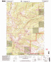
2000 Map of Ramshorn Peak
USGS Topo · Published 2005About this map
Gallatin National Forest dominates this high-altitude terrain at the turn of the 21st century, defined by a complex drainage system that feeds the surrounding valleys. The landscape is punctuated by prominent summits including Eaglehead Mountain, Steamboat Mountain, and Ramshorn Peak, which gives the quadrangle its name. This area serves as a critical habitat corridor, encompassing the Gallatin State Wildlife Management Area and various ranger districts including Bozeman and Livingston.
Find a feature on this map
34 named features on this map. Tap any name to fly to it.
Don’t see what you’re looking for? This feature index may not catch every label — zoom into the map to look around manually.
Map Details
Editions of this 2000 Ramshorn Peak Map
This is the sole edition of this map. No revisions or reprints were ever made.
Other maps of this area

1888 · Three Forks
USGS Topo · 1:250,000

1891 · Livingston
USGS Topo · 1:250,000

1893 · Livingston
USGS Topo · 1:250,000

1894 · Three Forks
USGS Topo · 1:250,000

1895 · Three Forks
USGS Topo · 1:250,000

1947 · Bozeman
USGS Topo · 1:250,000

1948 · Bozeman
USGS Topo · 1:250,000

1955 · Bozeman
USGS Topo · 1:250,000

1955 · Garnet Mountain
USGS Topo · 1:62,500

1955 · Fridley Peak
USGS Topo · 1:62,500