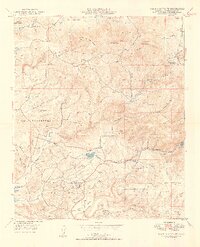
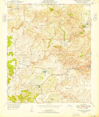
1949 Map of Rancho Santa Fe
USGS Topo · Published 1949About this map
Rancho Santa Fe and its surrounding inland valleys are captured here just as post-war development began to reshape this part of San Diego County. The map details the transition from large land holdings like the Osuna and Fairbanks Ranch to more defined residential clusters such as Olivenhain and Harmony Grove. This era shows a landscape where agriculture and resource extraction still maintained a heavy footprint, evidenced by the Pyrophyllite Mine and a Stone Quarry (Aban'd) near the San Dieguito River. The complex water system, crucial for the region's growth, is prominently displayed through the San Dieguito Reservoir and the western edge of Lake Hodges. Dominating the northern horizon are high points like Double Peak and Mt. Whitney, overlooking the winding courses of Escondido Creek and San Elijo Creek.
Find a feature on this map
26 named features on this map. Tap any name to fly to it.
Don’t see what you’re looking for? This feature index may not catch every label — zoom into the map to look around manually.
Map Details
Editions of this 1949 Rancho Santa Fe Map
2 editions found
Other maps of this area

1893 · Oceanside
USGS Topo · 1:62,500

1893 · Escondido
USGS Topo · 1:62,500

1898 · Oceanside
USGS Topo · 1:62,500

1901 · Escondido
USGS Topo · 1:62,500

1901 · Oceanside
USGS Topo · 1:62,500

1901 · San Luis Rey
USGS Topo · 1:125,000

1903 · La Jolla
USGS Topo · 1:62,500

1904 · Southern California Sheet No. 2
USGS Topo · 1:250,000

1930 · La Jolla
USGS Topo · 1:62,500

1942 · Poway Valley
USGS Topo · 1:31,680