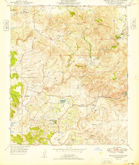
1949 Map of Rancho Santa Fe
USGS Topo · Published 1949About this map
Rancho Santa Fe and the surrounding coastal valleys of San Diego County are captured here just after the war, showing a landscape defined by historic ranchos and early agricultural settlements. The planned community at the Golf Course sits at the heart of the map, while older outposts like Olivenhain and Harmony Grove mark the transition toward the inland hills. The terrain is deeply carved by the San Dieguito River and Escondido Creek, leading toward Lake Hodges and the San Elijo Lagoon. This 1949 edition provides a look at the region's early industrial and cultural history, noting local resources like a Pyrophyllite Mine and a Stone Quarry (Aban'd) alongside ancient Petroglyphs near Mt Whitney. It reflects a brief window when the area's massive Spanish land grant legacy, seen in Los Encenitos and Rancho de los Quiotes, still dictated the layout of the land.
Find a feature on this map
30 named features on this map. Tap any name to fly to it.
Don’t see what you’re looking for? This feature index may not catch every label — zoom into the map to look around manually.
Map Details
Editions of this 1949 Rancho Santa Fe Map
2 editions found
Other maps of this area

1893 · Oceanside
USGS Topo · 1:62,500

1893 · Escondido
USGS Topo · 1:62,500

1898 · Oceanside
USGS Topo · 1:62,500

1901 · Escondido
USGS Topo · 1:62,500

1901 · Oceanside
USGS Topo · 1:62,500

1901 · San Luis Rey
USGS Topo · 1:125,000

1903 · La Jolla
USGS Topo · 1:62,500

1904 · Southern California Sheet No. 2
USGS Topo · 1:250,000

1930 · La Jolla
USGS Topo · 1:62,500

1942 · Poway Valley
USGS Topo · 1:31,680