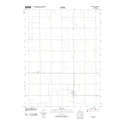
2009 Map of Randall
USGS Topo · Published 2009About this map
Randall sits at the intersection of a vast agricultural grid in Jewell County, appearing here as a focused center of settlement surrounded by the drainages of the Kansas plains. The landscape is defined by the winding paths of Buffalo Creek, Prairie Creek, and West Marsh Creek, which cut across the structured section lines and gravel roads. Local history and genealogy are anchored by the Wallace Cemetery, located just north of State Hwy 148. This survey highlights the spatial relationship between the town's core streets, like Main St and 5th St, and the outlying farmsteads that rely on the regional corridors of Randall Rd and the highway for connectivity.
Find a feature on this map
10 named features on this map. Tap any name to fly to it.
Don’t see what you’re looking for? This feature index may not catch every label — zoom into the map to look around manually.
Map Details
Editions of this 2009 Randall Map
This is the sole edition of this map. No revisions or reprints were ever made.
Other maps of this area

1892 · Concordia
USGS Topo · 1:125,000

1894 · Mankato
USGS Topo · 1:125,000

1955 · Manhattan
USGS Topo · 1:250,000

1955 · Beloit
USGS Topo · 1:250,000

1956 · Manhattan
USGS Topo · 1:250,000

1957 · Manhattan
USGS Topo · 1:250,000

1959 · Beloit
USGS Topo · 1:250,000

1962 · Jewell SE
USGS Topo · 1:24,000

1962 · Jewell SW
USGS Topo · 1:24,000
1966 · Scottsville
USGS Topo · 1:24,000