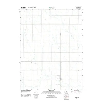
2012 Map of Randall
USGS Topo · Published 2012About this map
The town of Randall serves as the central hub for this portion of southern Jewell County, situated along the banks of Buffalo Cr. The landscape is defined by the winding paths of several drainage systems, including Spring Cr, Prairie Cr, and W Marsh Cr, which cut through the agricultural plains. For those researching local history or genealogy, the map identifies key community sites such as the Randall Cem and the more isolated Wallace Cem to the northwest. The town layout is clearly delineated with specific street names like Main St and Water St, alongside the central Po. This survey reflects the enduring character of a rural Kansas farming community, where the road network follows a strict sectional grid, interrupted only by the natural meanders of the creeks.
Find a feature on this map
14 named features on this map. Tap any name to fly to it.
Don’t see what you’re looking for? This feature index may not catch every label — zoom into the map to look around manually.
Map Details
Editions of this 2012 Randall Map
This is the sole edition of this map. No revisions or reprints were ever made.
Other maps of this area

1892 · Concordia
USGS Topo · 1:125,000

1894 · Mankato
USGS Topo · 1:125,000

1955 · Manhattan
USGS Topo · 1:250,000

1955 · Beloit
USGS Topo · 1:250,000

1956 · Manhattan
USGS Topo · 1:250,000

1957 · Manhattan
USGS Topo · 1:250,000

1959 · Beloit
USGS Topo · 1:250,000

1962 · Jewell SE
USGS Topo · 1:24,000

1962 · Jewell SW
USGS Topo · 1:24,000
1966 · Scottsville
USGS Topo · 1:24,000