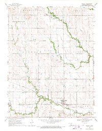
1969 Map of Randall
USGS Topo · Published 1971About this map
Randall serves as the central hub of this north-central Kansas landscape, situated where the Missouri Pacific railroad corridor cuts through the agricultural heartland of Jewell County. The town is defined by its grid layout south of the tracks, bordered to the south by the winding course of Buffalo Creek. This area illustrates a typical late-1960s rural economy, where the rail line provided a critical link for transporting products from the numerous quarries and gravel pits scattered across the surrounding townships.
Find a feature on this map
18 named features on this map. Tap any name to fly to it.
Don’t see what you’re looking for? This feature index may not catch every label — zoom into the map to look around manually.
Map Details
Editions of this 1969 Randall Map
This is the sole edition of this map. No revisions or reprints were ever made.
Other maps of this area

1892 · Concordia
USGS Topo · 1:125,000

1894 · Mankato
USGS Topo · 1:125,000

1955 · Manhattan
USGS Topo · 1:250,000

1955 · Beloit
USGS Topo · 1:250,000

1956 · Manhattan
USGS Topo · 1:250,000

1957 · Manhattan
USGS Topo · 1:250,000

1959 · Beloit
USGS Topo · 1:250,000

1962 · Jewell SE
USGS Topo · 1:24,000

1962 · Jewell SW
USGS Topo · 1:24,000
1966 · Scottsville
USGS Topo · 1:24,000