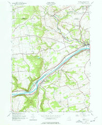
1944 Map of Randall
USGS Topo · Published 1977About this map
The Mohawk River corridor dominates this landscape, serving as the primary artery for both transportation and industry in the mid-1940s. The historic Erie Canal runs parallel to the river, threading through the twin river towns of Fonda and Fultonville, which serve as focal points for the region's development. This survey, based on 1940s field data with later revisions for the state highway system, documents the dense network of rural infrastructure, including a significant number of numbered schools such as School No 10 and School No 3. Notable landmarks like the Tekakwitha Friary and the County Home provide insight into the social and religious fabric of the era. The terrain is marked by distinctive geological features like the prominent bluffs of Big Nose and Little Nose, which constrict the river valley and shaped the path of the New York Central railroad lines.
Find a feature on this map
40 named features on this map. Tap any name to fly to it.
Don’t see what you’re looking for? This feature index may not catch every label — zoom into the map to look around manually.
Map Details
Editions of this 1944 Randall Map
3 editions found
Other maps of this area

1896 · Fonda
USGS Topo · 1:62,500

1898 · Fonda
USGS Topo · 1:62,500

1898 · Canajoharie
USGS Topo · 1:62,500

1900 · Canajoharie
USGS Topo · 1:62,500

1901 · Lassellsville
USGS Topo · 1:62,500

1902 · Canajoharie
USGS Topo · 1:62,500

1902 · Fonda
USGS Topo · 1:62,500

1903 · Gloversville
USGS Topo · 1:62,500

1903 · Lassellsville
USGS Topo · 1:62,500

1943 · Gloversville
USGS Topo · 1:62,500