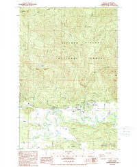
1989 Map of Randle
USGS Topo · Published 1989About this map
The Cowlitz River carves a winding path through this portion of Lewis County, where the valley floor meets the rising peaks of the Gifford Pinchot National Forest. The settlement of Randle serves as a central hub, situated near the Randle Ranger Sta and the White Pass High Sch. This late-1980s landscape is characterized by the juxtaposition of community infrastructure, such as the Substation and Golf Course, against the high-elevation terrain of Watch Mountain and Kiona Peak. Evidence of local industry and utility is visible through multiple Quarry and Borrow Pit sites. The drainage network is particularly dense, with numerous tributaries like Silver Creek, Siler Creek, and Hampton Creek descending from the timbered ridges to the river valley below.
Find a feature on this map
43 named features on this map. Tap any name to fly to it.
Don’t see what you’re looking for? This feature index may not catch every label — zoom into the map to look around manually.
Map Details
Editions of this 1989 Randle Map
This is the sole edition of this map. No revisions or reprints were ever made.
Other maps of this area

1919 · Mount St Helens
USGS Topo · 1:125,000

1924 · Mt Rainier
USGS Topo · 1:96,000

1926 · Steamboat Mtn
USGS Topo · 1:125,000

1928 · Mt Rainier
USGS Topo · 1:125,000

1931 · Steamboat Mtn
USGS Topo · 1:125,000

1937 · Eatonville
USGS Topo · 1:125,000

1950 · Yakima
USGS Topo · 1:250,000

1953 · Hoquiam
USGS Topo · 1:250,000

1956 · Mineral
USGS Topo · 1:62,500

1957 · Hoquiam
USGS Topo · 1:250,000