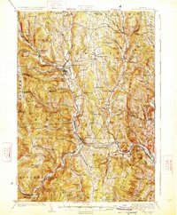
1926 Map of Randolph
USGS Topo · Published 1926About this map
Bethel serves as a central hub at the confluence of the White River and its branches, where the Central Vermont Ry corridor dictates the valley's development. This 1920s survey illustrates a rural landscape defined by an exceptionally dense network of one-room district schools, including Lost Nation School, Riford Brook School, and Whitcomb Hill School, reflecting the era's localized educational structure. Industrial and commemorative landmarks are evident in the Bethel Granite Quarry and the General Thomas Monument, while local tradition is preserved at the Old Church near Bethel Gilead. The topography is a complex of named peaks such as Blueberry Mtn and Mt Olympus, with the Third Branch and Second Branch carving deep valleys that host long-settled villages like Randolph and South Royalton. Family history is deeply embedded in features like Kents Lodge and Cowdrey Outlook, providing clear spatial context for the early 20th-century population.
Find a feature on this map
121 named features on this map. Tap any name to fly to it.
Don’t see what you’re looking for? This feature index may not catch every label — zoom into the map to look around manually.
Map Details
Editions of this 1926 Randolph Map
5 editions found

Other maps of this area

1891 · Rutland
USGS Topo · 1:62,500

1893 · Rutland
USGS Topo · 1:62,500

1896 · Strafford
USGS Topo · 1:62,500

1906 · Hanover
USGS Topo · 1:62,500

1908 · Hanover
USGS Topo · 1:62,500

1911 · Woodstock
USGS Topo · 1:62,500

1913 · Woodstock
USGS Topo · 1:62,500

1915 · Rochester
USGS Topo · 1:62,500

1917 · Rochester
USGS Topo · 1:62,500

1919 · Royalton
USGS Topo · 1:62,500