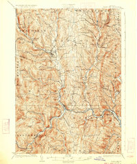
1926 Map of Randolph
USGS Topo · Published 1933About this map
Bethel Granite Quarry stands as a significant industrial landmark in this mid-1920s survey of the central Vermont highlands. The landscape is defined by the three branches of the White River, which carved deep valleys that dictate the placement of towns and transit. Along the Third Branch, the Central Vermont RR connects settlements like Randolph and Bethel, while the smaller mountain drainages are dotted with dozens of numbered and named schoolhouses, including the Old Stone School and the remote Lost Nation School.
Find a feature on this map
125 named features on this map. Tap any name to fly to it.
Don’t see what you’re looking for? This feature index may not catch every label — zoom into the map to look around manually.
Map Details
Editions of this 1926 Randolph Map
5 editions found

Other maps of this area

1891 · Rutland
USGS Topo · 1:62,500

1893 · Rutland
USGS Topo · 1:62,500

1896 · Strafford
USGS Topo · 1:62,500

1906 · Hanover
USGS Topo · 1:62,500

1908 · Hanover
USGS Topo · 1:62,500

1911 · Woodstock
USGS Topo · 1:62,500

1913 · Woodstock
USGS Topo · 1:62,500

1915 · Rochester
USGS Topo · 1:62,500

1917 · Rochester
USGS Topo · 1:62,500

1919 · Royalton
USGS Topo · 1:62,500