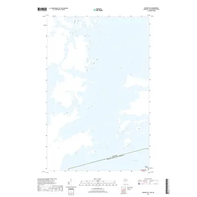
2019 Map of Ranier OE N
USGS Topo · Published 2019About this map
Rainy Lake dominates this northern frontier landscape, where the waters of the Minnesota-Ontario border weave through a complex network of inlets and peninsulas. Located north of Ranier, this 2019 survey documents the intricate shoreline and numerous unnamed island clusters that characterize this part of Koochiching County. The southern portion of the map is punctuated by Fransen Island, situated just above the international boundary line. The survey clearly delineates the border between Canada and the United States of America, illustrating how the political line bisects the open water and island chains of this northern waterway. This map provides a clear look at the modern topography of the lake before any further shifts in shoreline or development, anchored by the township coordinates of t71n r23w.
Find a feature on this map
4 named features on this map. Tap any name to fly to it.
Don’t see what you’re looking for? This feature index may not catch every label — zoom into the map to look around manually.
Map Details
Editions of this 2019 Ranier OE N Map
This is the sole edition of this map. No revisions or reprints were ever made.
Other maps of this area

1919 · International Falls
USGS Topo · 1:62,500

1954 · International Falls
USGS Topo · 1:250,000

1957 · International Falls
USGS Topo · 1:250,000

1958 · International Falls
USGS Topo · 1:250,000

1963 · Ranier
USGS Topo · 1:24,000

1969 · Island View
USGS Topo · 1:24,000

1969 · Ranier
USGS Topo · 1:24,000
1969 · International Falls
USGS Topo · 1:24,000
1978 · International Falls
USGS Topo · 1:100,000
1999 · International Falls
USGS Topo · 1:24,000