
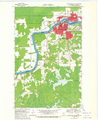
1963 Map of Ranier
USGS Topo · Published 1987About this map
Rainy Lake and the Rainy River define the international border at this northern Minnesota crossing, where industrial and transportation networks converge. The village of Ranier serves as a focal point for rail traffic, situated at the junction of several major lines including the Canadian National, the Duluth Winnipeg and Pacific, and the Minnesota Dakota and Western. This 1960s perspective, updated with 1980s revisions, illustrates the complex hydrology of the region, from the open waters of Sand Bay and Jackfish Bay to the marshy lowlands surrounding Rat Root River and Rat Root Lake. The map reveals the settlement patterns of Jameson and Falls Junction, along with local landmarks like Point-O-Pines Ch. To the south, the landscape transitions into dense wetlands and forests, crisscrossed by a Winter Trail, reflecting the seasonal character of movement through this borderland terrain.
Find a feature on this map
30 named features on this map. Tap any name to fly to it.
Don’t see what you’re looking for? This feature index may not catch every label — zoom into the map to look around manually.
Map Details
Editions of this 1963 Ranier Map
This is the sole edition of this map. No revisions or reprints were ever made.
Other maps of this area

1919 · International Falls
USGS Topo · 1:62,500

1954 · International Falls
USGS Topo · 1:250,000

1957 · International Falls
USGS Topo · 1:250,000

1958 · International Falls
USGS Topo · 1:250,000

1969 · Island View
USGS Topo · 1:24,000

1969 · Ericsburg NW
USGS Topo · 1:24,000

1969 · Ericsburg
USGS Topo · 1:24,000

1969 · Ray
USGS Topo · 1:24,000

1969 · Ranier
USGS Topo · 1:24,000
1969 · International Falls
USGS Topo · 1:24,000