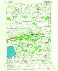
1965 Map of Ransomville
USGS Topo · Published 1968About this map
The Tuscarora Indian Reservation occupies the center of this Niagara County landscape, set against the striking topography of the Niagara Escarpment. In the mid-1960s, the region was characterized by a mix of established agricultural lands, emerging suburban clusters like Falcon Manor, and institutional sites such as the Niagara-Wheatfield High Sch. The rail corridors of the New York Central Railroad and Erie-Lackawanna provided vital links between the rural hamlets of Ransomville and Sanborn.
Find a feature on this map
67 named features on this map. Tap any name to fly to it.
Don’t see what you’re looking for? This feature index may not catch every label — zoom into the map to look around manually.
Map Details
Editions of this 1965 Ransomville Map
This is the sole edition of this map. No revisions or reprints were ever made.
Other maps of this area

1894 · Niagara Falls
USGS Topo · 1:62,500

1894 · Wilson
USGS Topo · 1:62,500

1896 · Niagara Falls
USGS Topo · 1:62,500

1897 · Tonawanda
USGS Topo · 1:62,500

1899 · Niagara
USGS Topo · 1:125,000

1900 · Wilson
USGS Topo · 1:62,500

1900 · Tonawanda
USGS Topo · 1:62,500

1900 · Niagara Falls
USGS Topo · 1:62,500

1901 · Niagara Falls
USGS Topo · 1:62,500

1901 · Tonawanda
USGS Topo · 1:62,500