1963 Map of Rantoul
USGS Topo · Published 1983About this map
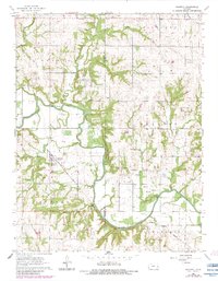
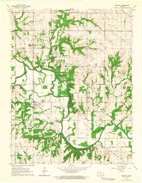
Rantoul serves as the focal point for this survey of the eastern Kansas landscape, situated where the Missouri Pacific railroad cuts through the lowlands. The winding path of the Marais Des Cygnes River dominates the topography, joined by tributaries such as Hickory Creek and Turkey Creek. This mid-century view documents a rural community defined by its township divisions and local institutions. Scattered across the countryside are markers of early local life, including the Victory Sch and various houses of worship like New Hope Ch and Spring Ridge Ch. The map also captures the industrial activity of the period with several oil wells and a Quarry located near the border of Franklin and Miami counties. Genealogists can find significant value in the documentation of the Pleasant Valley Cem and Howard Cem, which anchor the local family history of this agricultural region.
Find a feature on this map
21 named features on this map. Tap any name to fly to it.
Don’t see what you’re looking for? This feature index may not catch every label — zoom into the map to look around manually.
Map Details
Editions of this 1963 Rantoul Map
2 editions found
Other maps of this area

1885 · Garnett
USGS Topo · 1:125,000

1885 · Lawrence
USGS Topo · 1:125,000

1887 · Olathe
USGS Topo · 1:125,000

1887 · Mound City
USGS Topo · 1:125,000

1889 · Lawrence
USGS Topo · 1:125,000

1893 · Mound City
USGS Topo · 1:125,000

1893 · Olathe
USGS Topo · 1:125,000

1894 · Garnett
USGS Topo · 1:125,000

1947 · Lawrence
USGS Topo · 1:250,000

1950 · Lawrence
USGS Topo · 1:250,000