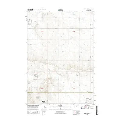
2015 Map of Rapid City NW
USGS Topo · Published 2015About this map
Ashland Heights and the northern outskirts of Rapid City anchor the southern portion of this 2015 survey, where the prairie begins to transition toward the Black Hills. The landscape is defined by the winding drainages of Boxelder Creek and Elk Creek, which cut through the high plains. While the southern sections show modern residential expansion near Box Elder, the northern reaches remain primarily rural, marked by long section roads like Elk Creek Rd and 218th St. One of the most significant local landmarks is the Elk Vale Cem, situated along Elk Creek Rd as it crosses the northern township line. This map captures the specific boundary between Meade Co and Pennington Co, illustrating how the suburban growth of the Rapid City area meets the agricultural tradition of the surrounding creeks, including Dry Creek and Morris Creek.
Find a feature on this map
61 named features on this map. Tap any name to fly to it.
Don’t see what you’re looking for? This feature index may not catch every label — zoom into the map to look around manually.
Map Details
Editions of this 2015 Rapid City NW Map
This is the sole edition of this map. No revisions or reprints were ever made.
Other maps of this area

1893 · Rapid
USGS Topo · 1:125,000

1898 · Rapid
USGS Topo · 1:125,000

1903 · Rapid
USGS Topo · 1:125,000

1953 · Bend
USGS Topo · 1:24,000

1953 · Rapid City 1 SW
USGS Topo · 1:24,000

1953 · Boxelder
USGS Topo · 1:24,000

1953 · Blackhawk
USGS Topo · 1:24,000

1953 · Rapid City East
USGS Topo · 1:24,000

1953 · Rapid City NW
USGS Topo · 1:24,000

1953 · Rapid City West
USGS Topo · 1:24,000