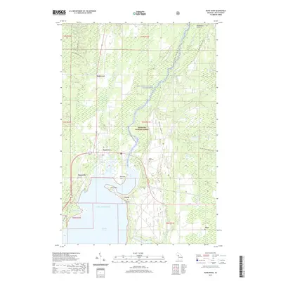
2019 Map of Rapid River
USGS Topo · Published 2019About this map
Little Bay de Noc forms the southern boundary of this Delta County landscape, where the waters of the Rapid River and the Whitefish Wild and Scenic River converge before emptying into Lake Michigan. The settlement of Rapid River serves as a central hub, flanked by the smaller communities of Masonville, Maplewood, and Garth. This 2019 survey illustrates a landscape heavily defined by its recreational and environmental protections, with much of the northern terrain encompassed by the Hiawatha National Forest. Local history is preserved in several small burial sites, including the Rapid River Cemetery, the Garth Point Cemetery, and the isolated McLeod Grave. The mapping of the Bay de Noc - Grand Island trail and the Rapid River Ski trails reflects the modern transition of the Upper Peninsula economy toward seasonal tourism and outdoor heritage.
Find a feature on this map
38 named features on this map. Tap any name to fly to it.
Don’t see what you’re looking for? This feature index may not catch every label — zoom into the map to look around manually.
Map Details
Editions of this 2019 Rapid River Map
This is the sole edition of this map. No revisions or reprints were ever made.
Other maps of this area

1932 · Gladstone NE
USGS Topo · 1:31,680

1932 · Rapid River NE
USGS Topo · 1:31,680

1932 · Trenary SW
USGS Topo · 1:31,680

1932 · Gladstone SE
USGS Topo · 1:31,680

1932 · Rapid River NW
USGS Topo · 1:31,680

1932 · Trenary SE
USGS Topo · 1:31,680

1932 · Rock SE
USGS Topo · 1:31,680

1932 · Rapid River SE
USGS Topo · 1:31,680

1932 · Rapid River SW
USGS Topo · 1:31,680

1954 · Escanaba
USGS Topo · 1:250,000