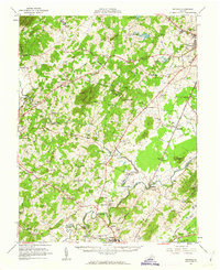
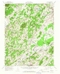
1961 Map of Rapidan
USGS Topo · Published 1963About this map
The Southern Railway corridor anchors this rural landscape at the crossroads of Madison, Culpeper, and Orange Counties. Small agricultural settlements and community hubs like Brightwood, Locust Dale, and Mitchells dot the terrain between the Robinson River and the Rapidan River. The presence of established institutions such as the Woodberry Forest Sch and George Washington Carver Sch indicates a region with deep-rooted educational and social infrastructure.
Find a feature on this map
103 named features on this map. Tap any name to fly to it.
Don’t see what you’re looking for? This feature index may not catch every label — zoom into the map to look around manually.
Map Details
Editions of this 1961 Rapidan Map
2 editions found
Other maps of this area

1887 · Spottsylvania
USGS Topo · 1:125,000

1892 · Spottsylvania
USGS Topo · 1:125,000

1892 · Gordonsville
USGS Topo · 1:125,000

1893 · Luray
USGS Topo · 1:125,000

1894 · Warrenton
USGS Topo · 1:125,000

1894 · Warrenton
USGS Topo · 1:62,500

1905 · Luray
USGS Topo · 1:125,000

1927 · Remington
USGS Topo · 1:48,000

1929 · Stony Man
USGS Topo · 1:48,000

1930 · Warrenton
USGS Topo · 1:62,500