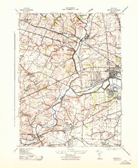
1943 Map of Raritan
USGS Topo · Published 1943About this map
The Bound Brook War Aid Depot and the sprawling Duke Estate anchor this wartime landscape in Somerset County, where the industrial and agricultural worlds of central New Jersey meet. Significant logistical and manufacturing infrastructure is evident through the Raritan Factory Shaft and the complex rail network of the Central Railroad of New Jersey and Lehigh Valley lines.
Find a feature on this map
46 named features on this map. Tap any name to fly to it.
Don’t see what you’re looking for? This feature index may not catch every label — zoom into the map to look around manually.
Map Details
Editions of this 1943 Raritan Map
This is the sole edition of this map. No revisions or reprints were ever made.
Other maps of this area

1888 · Princeton
USGS Topo · 1:62,500

1890 · High Bridge
USGS Topo · 1:62,500

1890 · Lambertville
USGS Topo · 1:62,500

1891 · Somerville
USGS Topo · 1:62,500

1891 · Lambertville
USGS Topo · 1:62,500

1893 · Somerville
USGS Topo · 1:62,500

1894 · Princeton
USGS Topo · 1:62,500

1894 · Lambertville
USGS Topo · 1:62,500

1898 · High Bridge
USGS Topo · 1:62,500

1898 · Somerville
USGS Topo · 1:62,500
Featured Places
- Bridgewater Township, NJ
- Hillsborough Township, NJ
- Readington Township, NJ
- Somerville, NJ
- Bedminster Township, NJ