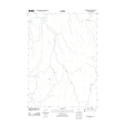
2012 Map of Rathbun Ranch
USGS Topo · Published 2012About this map
Rathbun Ranch and several other legacy livestock operations define this stretch of the Wyoming high desert, where water management is the primary driver of settlement. The map documents a sophisticated network of arid-land hydrology, centered on the Rathbun Irrigation Number 1 Reservoir and the Kirby Reservoir, which capture seasonal flows from Kirby Cr and the Dry Fork. These reservoirs support ranching outposts like the Hayes Winter Ranch and Gardner Winter Ranch, specialized sites for managing herds during the harsh Wyoming winters. The terrain is marked by distinctive features like Hall Butte and the Little V-H Draw, while the presence of the Day Homestead alongside modern infrastructure like Kirby Creek Rd illustrates the long-term continuity of family land tenure in Hot Springs County.
Find a feature on this map
23 named features on this map. Tap any name to fly to it.
Don’t see what you’re looking for? This feature index may not catch every label — zoom into the map to look around manually.
Map Details
Editions of this 2012 Rathbun Ranch Map
This is the sole edition of this map. No revisions or reprints were ever made.
Other maps of this area

1952 · Rathbun Ranch
USGS Topo · 1:24,000

1952 · Arapahoe Butte
USGS Topo · 1:24,000

1952 · De Pass
USGS Topo · 1:24,000

1952 · Guffy Peak
USGS Topo · 1:24,000

1952 · Bull Mountain
USGS Topo · 1:24,000

1955 · Arminto
USGS Topo · 1:250,000

1957 · Rathbun Ranch
USGS Topo · 1:24,000

1958 · Arminto
USGS Topo · 1:250,000

1960 · Coyote Hill
USGS Topo · 1:24,000
1960 · Blue Hill
USGS Topo · 1:24,000