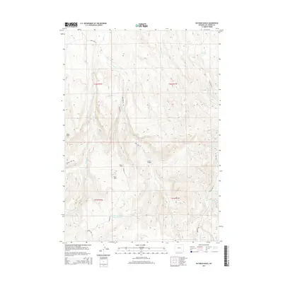
2015 Map of Rathbun Ranch
USGS Topo · Published 2015About this map
Rathbun Ranch serves as the focal point for this section of Hot Springs County, where land management and water access define the rural landscape. In an area marked by numerous drainages and forks, the infrastructure of the Rathbun Irrigation Number 1 Reservoir and Kirby Reservoir illustrates the critical role of water storage in this high-desert environment. The terrain is characterized by named geographical features like Hall Butte and distinctive valleys such as Olsen Draw and Little V-H Draw. Transportation across this rugged topography follows the natural contours, with Kirby Creek Rd and Buffalo Creek Rd providing the primary links between remote ranch sites and the larger watershed of Kirby Cr. This 2015 survey provides a clear view of the modern land divisions and water management systems used to sustain agriculture in the region.
Find a feature on this map
27 named features on this map. Tap any name to fly to it.
Don’t see what you’re looking for? This feature index may not catch every label — zoom into the map to look around manually.
Map Details
Editions of this 2015 Rathbun Ranch Map
This is the sole edition of this map. No revisions or reprints were ever made.
Other maps of this area

1952 · Rathbun Ranch
USGS Topo · 1:24,000

1952 · Arapahoe Butte
USGS Topo · 1:24,000

1952 · De Pass
USGS Topo · 1:24,000

1952 · Guffy Peak
USGS Topo · 1:24,000

1952 · Bull Mountain
USGS Topo · 1:24,000

1955 · Arminto
USGS Topo · 1:250,000

1957 · Rathbun Ranch
USGS Topo · 1:24,000

1958 · Arminto
USGS Topo · 1:250,000

1960 · Coyote Hill
USGS Topo · 1:24,000
1960 · Blue Hill
USGS Topo · 1:24,000