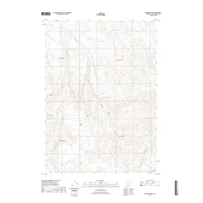
2017 Map of Rathbun Ranch
USGS Topo · Published 2017About this map
Rathbun Ranch serves as a central landmark in this high-desert landscape of Hot Springs County, where intricate drainage systems define the rugged topography. The convergence of Kirby Cr, E Kirby Cr, and the Ackles Fork underscores the importance of water management in this arid region, evidenced by the Kirby Reservoir and the Rathbun Irrigation Number 1 Reservoir. These features reflect the long-standing ranching and irrigation traditions necessary to sustain operations in the Wyoming basins.
Find a feature on this map
23 named features on this map. Tap any name to fly to it.
Don’t see what you’re looking for? This feature index may not catch every label — zoom into the map to look around manually.
Map Details
Editions of this 2017 Rathbun Ranch Map
This is the sole edition of this map. No revisions or reprints were ever made.
Other maps of this area

1952 · Rathbun Ranch
USGS Topo · 1:24,000

1952 · Arapahoe Butte
USGS Topo · 1:24,000

1952 · De Pass
USGS Topo · 1:24,000

1952 · Guffy Peak
USGS Topo · 1:24,000

1952 · Bull Mountain
USGS Topo · 1:24,000

1955 · Arminto
USGS Topo · 1:250,000

1957 · Rathbun Ranch
USGS Topo · 1:24,000

1958 · Arminto
USGS Topo · 1:250,000

1960 · Coyote Hill
USGS Topo · 1:24,000
1960 · Blue Hill
USGS Topo · 1:24,000