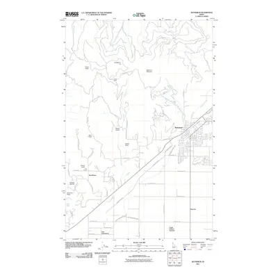
2011 Map of Rathdrum
USGS Topo · Published 2011About this map
Rathdrum serves as the primary hub on this Kootenai County survey, where the grid of the town site meets the diagonal transit lines of the railway. The landscape transitions from the residential developments at Hidden Valley and Scenic Lodge to the more open agricultural and drainage patterns of the south, characterized by the East Greenacres Main Ditch and East Greenacres North Ditch. These waterways support the outlying areas of East Greenacres and Haycrop, illustrating the regional reliance on managed irrigation for local land use.
Find a feature on this map
56 named features on this map. Tap any name to fly to it.
Don’t see what you’re looking for? This feature index may not catch every label — zoom into the map to look around manually.
Map Details
Editions of this 2011 Rathdrum Map
This is the sole edition of this map. No revisions or reprints were ever made.
Other maps of this area

1901 · Spokane
USGS Topo · 1:125,000

1903 · Rathdrum
USGS Topo · 1:125,000

1943 · Mt Spokane
USGS Topo · 1:62,500

1949 · Greenacres
USGS Topo · 1:62,500

1950 · Mt Spokane
USGS Topo · 1:62,500

1951 · Greenacres
USGS Topo · 1:62,500

1955 · Spokane
USGS Topo · 1:250,000

1957 · Coeur D'Alene
USGS Topo · 1:62,500

1958 · Spokane
USGS Topo · 1:250,000

1961 · Hayden
USGS Topo · 1:24,000