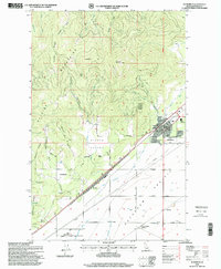
1996 Map of Rathdrum
USGS Topo · Published 1999About this map
Rathdrum Mountain and the southern slopes of the Selkirk Mountains dominate the northern landscape, where Rathdrum sits at the foot of these high ridges. This late 20th-century survey shows a community defined by its water management and transport links, with the Main Ditch and East Greenacres Ditch feeding the flat, fertile Rathdrum Prairie to the south. Residential and agricultural patterns are clear in the clustering around Howelltown and Georgetown, while the town center features vital community infrastructure such as the Grange Hall and Rathdrum Elem Sch. The transition from the rugged timbered slopes of the Coeur d'Alene National Forest to the industrial utility of the Railroad Switching Yard at Coeur d'Alene Junction reflects the region's diverse economic base during this era.
Find a feature on this map
57 named features on this map. Tap any name to fly to it.
Don’t see what you’re looking for? This feature index may not catch every label — zoom into the map to look around manually.
Map Details
Editions of this 1996 Rathdrum Map
This is the sole edition of this map. No revisions or reprints were ever made.
Other maps of this area

1901 · Spokane
USGS Topo · 1:125,000

1903 · Rathdrum
USGS Topo · 1:125,000

1943 · Mt Spokane
USGS Topo · 1:62,500

1949 · Greenacres
USGS Topo · 1:62,500

1950 · Mt Spokane
USGS Topo · 1:62,500

1951 · Greenacres
USGS Topo · 1:62,500

1955 · Spokane
USGS Topo · 1:250,000

1957 · Coeur D'Alene
USGS Topo · 1:62,500

1958 · Spokane
USGS Topo · 1:250,000

1961 · Hayden
USGS Topo · 1:24,000