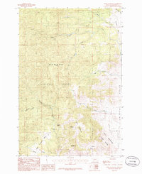
1985 Map of Ratio Mountain
USGS Topo · Published 1986About this map
Ratio Mountain dominates this mid-1980s landscape within the Deerlodge National Forest, where high-elevation drainage patterns define the territory. The map details a transition from the wooded heights of Goodwin Mountain and the Bull Mountain Game Range down to the open Whitetail Valley. Resource extraction is evident through several noted prospects and a mine shaft located near the State land boundary, suggesting a history of small-scale mineral exploration. Water sources are critical in this environment, marked by named features like Wildhorse Spring and Roadside Spring, which feed into a complex network of streams including Beaver Creek and the South Fork Beaver Creek. The presence of Poison Flats and Whitetail Basin indicates a geography carved by seasonal runoff and distinctive local landmarks used by generations of land managers and outdoorsmen.
Find a feature on this map
23 named features on this map. Tap any name to fly to it.
Don’t see what you’re looking for? This feature index may not catch every label — zoom into the map to look around manually.
Map Details
Editions of this 1985 Ratio Mountain Map
This is the sole edition of this map. No revisions or reprints were ever made.
Other maps of this area

1889 · Helena
USGS Topo · 1:250,000

1893 · Helena
USGS Topo · 1:250,000

1893 · Dillon
USGS Topo · 1:250,000

1899 · Boulder
USGS Topo · 1:125,000

1899 · Helena
USGS Topo · 1:250,000

1903 · Helena
USGS Topo · 1:250,000

1947 · Butte
USGS Topo · 1:250,000

1954 · Elk Park
USGS Topo · 1:62,500

1954 · Boulder
USGS Topo · 1:62,500

1955 · Dillon
USGS Topo · 1:250,000