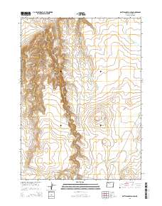
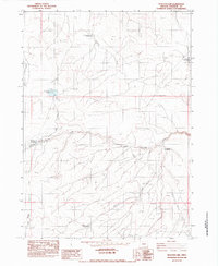
2014 Map of Rattlesnake Canyon
USGS Topo · Published 2014About this map
Rattlesnake Canyon and its associated watercourse, Rattlesnake Cr, dominate this high-desert landscape in southeastern Malheur County. The map details a complex system of drainage and water management, featuring named canyons like Woolhawk Canyon and Pistol Canyon alongside remote cattle-country infrastructure. Man-made water features such as the Upper Chimney Cr Reservoir, Lower Chimney Cr Reservoir, and Holding Corral Reservoir illustrate the vital importance of seasonal water storage in this arid environment. The presence of Coyote Spring and several reservoirs suggests a landscape primarily dedicated to rangeland and livestock, connected by primitive routes like the Rattle Snake Cutoff. Notable landmarks such as Little Grassy Mtn provide vertical relief in an area marked by rugged topography and ephemeral streams like Bull Cr and Little Antelope Cr.
Find a feature on this map
23 named features on this map. Tap any name to fly to it.
Don’t see what you’re looking for? This feature index may not catch every label — zoom into the map to look around manually.
Map Details
Editions of this 2014 Rattlesnake Canyon Map
This is the sole edition of this map. No revisions or reprints were ever made.
Other maps of this area

1955 · Jordan Valley
USGS Topo · 1:250,000

1957 · Jordan Valley
USGS Topo · 1:250,000

1958 · Jordan Valley
USGS Topo · 1:250,000

1979 · Bowden Ranch
USGS Topo · 1:24,000
1980 · Caviatta Ridge
USGS Topo · 1:24,000
1980 · Jackies Butte
USGS Topo · 1:24,000

1982 · Battle Mtn
USGS Topo · 1:24,000

1982 · Rattlesnake Canyon
USGS Topo · 1:24,000
1982 · Starvation Spring
USGS Topo · 1:24,000
1982 · Peacock Lake
USGS Topo · 1:24,000