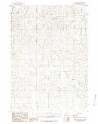
1984 Map of Rattlesnake Draw
USGS Topo · Published 1984About this map
Rocky Butte and Rattlesnake Butte dominate the high ground of this Campbell County landscape, serving as the primary landmarks in an area defined by its complex drainage network. The terrain is marked by a series of intermittent draws and creeks that converge toward the south and east, including the extensive course of North Porcupine Creek and the eponymous Rattlesnake Draw. The survey reveals a landscape largely devoid of concentrated settlement, instead highlighting the isolated named geographical features used by locals to navigate the open range. Watercourses like Butte Gulch, Billie Creek, and Tree Draw indicate the historical importance of seasonal water management in this Wyoming interior. The map provides a look at the rural survey sections and unimproved roads as they existed in the mid-1980s, documenting the natural landmarks of the region before significant modern development.
Find a feature on this map
12 named features on this map. Tap any name to fly to it.
Don’t see what you’re looking for? This feature index may not catch every label — zoom into the map to look around manually.
Map Details
Editions of this 1984 Rattlesnake Draw Map
This is the sole edition of this map. No revisions or reprints were ever made.
Other maps of this area

1955 · Newcastle
USGS Topo · 1:250,000

1958 · Newcastle
USGS Topo · 1:250,000

1959 · North Star School
USGS Topo · 1:62,500

1960 · Turnercrest
USGS Topo · 1:62,500

1971 · Reno Junction
USGS Topo · 1:24,000

1971 · Little Thunder Reservoir
USGS Topo · 1:24,000

1971 · Teckla SW
USGS Topo · 1:24,000

1974 · Reno Junction
USGS Topo · 1:100,000

1984 · Turnercrest
USGS Topo · 1:24,000
1984 · Reno Flats
USGS Topo · 1:24,000