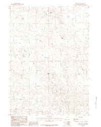
1984 Map of Reno Flats
USGS Topo · Published 1984About this map
Reno Flats characterizes this stretch of Campbell County, where the high plains landscape is defined by its intermittent drainage systems and essential water sources. Surveyed in the late 1970s and early 1980s, the map reveals a remote ranching environment where named springs like Hardwater Spring, Maycock Spring, and Rock Spring served as vital landmarks for navigation and livestock. The topographic detail shows the winding course of Little Reno Bates Creek as it moves through the flats, joined by the West Prong. This manuscript-based provisional study provides a look at the open range before extensive modern development, documenting the subtle terrain of Buck Draw and the isolated Cold Spring in a region where water dictated the patterns of human activity and land use.
Find a feature on this map
10 named features on this map. Tap any name to fly to it.
Don’t see what you’re looking for? This feature index may not catch every label — zoom into the map to look around manually.
Map Details
Editions of this 1984 Reno Flats Map
2 editions found
Other maps of this area

1955 · Newcastle
USGS Topo · 1:250,000

1958 · Newcastle
USGS Topo · 1:250,000

1959 · Betty Reservoir
USGS Topo · 1:62,500

1959 · Coal Draw
USGS Topo · 1:62,500

1960 · Turnercrest
USGS Topo · 1:62,500

1971 · Little Thunder Reservoir
USGS Topo · 1:24,000

1971 · Teckla SW
USGS Topo · 1:24,000

1974 · Reno Junction
USGS Topo · 1:100,000

1979 · Bill
USGS Topo · 1:100,000

1984 · Turnercrest
USGS Topo · 1:24,000