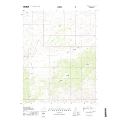
2018 Map of Rattlesnake Flat
USGS Topo · Published 2018About this map
Toiyabe National Forest lands dominate the southern portion of this desert landscape in Mineral County, where high-elevation terrain transitions between the Excelsior Mountains and the Garfield Hills. The area is characterized by significant topographic relief, peaking at Excelsior Mtn and providing a critical natural corridor for water at Summit Spring. This 2018 survey reveals a sparse network of forest development routes, such as Nat For Dev Rd 200, which provide access to remote high-country features like Rattlesnake Summit and the broad expanse of Rattlesnake Flat. The geography here illustrates the intersection of federal land management and the traditional basin-and-range topography of the Great Basin, where seasonal drainages like Rattlesnake Canyon define the travel routes through the arid peaks.
Find a feature on this map
14 named features on this map. Tap any name to fly to it.
Don’t see what you’re looking for? This feature index may not catch every label — zoom into the map to look around manually.
Map Details
Editions of this 2018 Rattlesnake Flat Map
This is the sole edition of this map. No revisions or reprints were ever made.
Other maps of this area

1909 · Hawthorne
USGS Topo · 1:250,000

1911 · Hawthorne
USGS Topo · 1:250,000

1915 · Hawthorne
USGS Topo · 1:250,000

1948 · Walker Lake
USGS Topo · 1:250,000

1955 · Powell Mtn
USGS Topo · 1:62,500

1957 · Walker Lake
USGS Topo · 1:250,000

1958 · Huntoon Valley
USGS Topo · 1:62,500

1962 · Walker Lake
USGS Topo · 1:250,000

1964 · Walker Lake
USGS Topo · 1:250,000

1967 · Pamlico
USGS Topo · 1:24,000