
1955 Map of Rattlesnake Lake NE
USGS Topo · Published 1956About this map
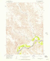
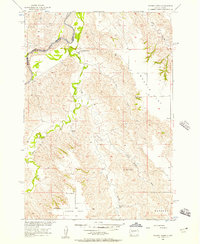
Cherry Creek meanders through the southern half of this mid-century survey, creating a lush corridor across the Ziebach County landscape. This 1955 field-checked study, conducted as part of the Department of the Interior program for the development of the Missouri River Basin, documents a vast expanse of unpopulated terrain defined by deep drainage systems and high plateaus. Significant topographical relief is visible where Straighthead Draw and Horn Draw cut through the central sections toward the main waterway. To the north, the headwaters of Little Cottonwood Creek and its East Fork define the watershed, while Little Dog Draw marks the western boundary. The map provides a precise record of the land before significant modern alterations, showing the intricate network of natural draws and benchmarks that guided early mid-century resource planning in South Dakota.
Find a feature on this map
6 named features on this map. Tap any name to fly to it.
Don’t see what you’re looking for? This feature index may not catch every label — zoom into the map to look around manually.
Map Details
Editions of this 1955 Rattlesnake Lake NE Map
This is the sole edition of this map. No revisions or reprints were ever made.
Other maps of this area

1954 · Pierre
USGS Topo · 1:250,000

1955 · Rattlesnake Lake SE
USGS Topo · 1:24,000

1955 · Rattlesnake Lake SW
USGS Topo · 1:24,000

1955 · Rattlesnake Lake
USGS Topo · 1:24,000
1956 · Cherry Creek NW
USGS Topo · 1:24,000
1956 · Cherry Creek
USGS Topo · 1:24,000

1958 · Pierre
USGS Topo · 1:250,000

1981 · High Elk Hill SW
USGS Topo · 1:24,000

1982 · Longbrake Ranch
USGS Topo · 1:24,000

1982 · Sears Dam
USGS Topo · 1:24,000