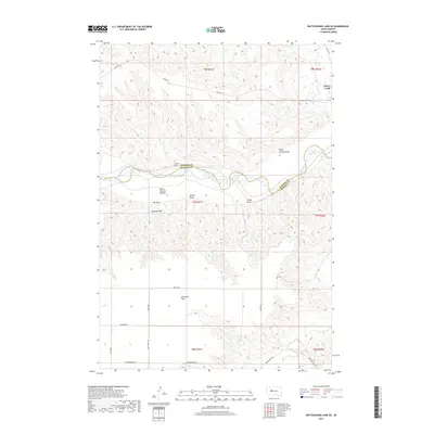
2017 Map of Rattlesnake Lake SE
USGS Topo · Published 2017About this map
The Cheyenne River carves a serpentine path through the northern plains of Ziebach and Haakon Counties, defining a landscape of deep draws and alluvial flats. This section of the South Dakota prairie is marked by isolated natural features like Beerwagon Spring and the expansive Milesville Flat, which suggests the agricultural and grazing potential of the late twentieth-century cattle country. The terrain is deeply eroded, as evidenced by named coulees such as Eagle Chasing Draw and White Thunder Bottom that drain toward the river. Transportation in this rural region relies on a network of Bureau of Indian Affairs routes, including Bia Hwy 11 and Bia HWY 8, alongside local tracks like Kirley Rd and Hardingrove Rd. The map illustrates a remote ranching landscape where seasonal waterways like Cherry Cr and Hump Cr are critical landmarks for navigation and land management.
Find a feature on this map
28 named features on this map. Tap any name to fly to it.
Don’t see what you’re looking for? This feature index may not catch every label — zoom into the map to look around manually.
Map Details
Editions of this 2017 Rattlesnake Lake SE Map
This is the sole edition of this map. No revisions or reprints were ever made.
Other maps of this area

1954 · Pierre
USGS Topo · 1:250,000

1955 · Rattlesnake Lake SE
USGS Topo · 1:24,000

1955 · Rattlesnake Lake SW
USGS Topo · 1:24,000

1955 · Rattlesnake Lake
USGS Topo · 1:24,000

1955 · Rattlesnake Lake NE
USGS Topo · 1:24,000

1956 · Cherry Creek NW
USGS Topo · 1:24,000

1956 · Cherry Creek
USGS Topo · 1:24,000

1958 · Pierre
USGS Topo · 1:250,000

1983 · Philip
USGS Topo · 1:100,000

1983 · Milesville
USGS Topo · 1:24,000