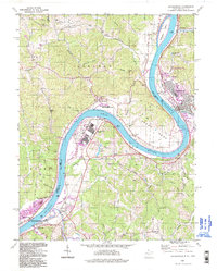
1994 Map of Ravenswood
USGS Topo · Published 1998About this map
The Ohio River dominates this landscape, carving a deep arc known as the Great Bend where West Virginia and Ohio meet. Along the fertile riverbanks, industrial infrastructure like the Ravenswood Works and a large Substation sits adjacent to the town of Ravenswood, reflecting the mid-century industrial development that defined this section of Jackson County. Rural life persists on the surrounding ridges, marked by a high density of family cemeteries and country churches, including the McKay and Parsons cemeteries, and houses of worship like Morse Chapel and Bethlehem Ch. The river's historical importance as a transit corridor is visible at Ripley Landing and the Lock and Dam No 23 near Apple Grove, while recreational areas like the Turkey Run Lake Public Fishing Area and Keraland Recreation Area show a transition toward modern land use.
Find a feature on this map
74 named features on this map. Tap any name to fly to it.
Don’t see what you’re looking for? This feature index may not catch every label — zoom into the map to look around manually.
Map Details
Editions of this 1994 Ravenswood Map
This is the sole edition of this map. No revisions or reprints were ever made.
Other maps of this area

1906 · Belleville
USGS Topo · 1:62,500

1907 · Keno
USGS Topo · 1:62,500

1907 · Ripley
USGS Topo · 1:62,500

1908 · Ravenswood
USGS Topo · 1:62,500

1924 · Belleville
USGS Topo · 1:62,500

1926 · Ravenswood
USGS Topo · 1:62,500

1926 · Belleville
USGS Topo · 1:62,500

1926 · Ripley
USGS Topo · 1:62,500

1928 · Ravenswood
USGS Topo · 1:62,500

1928 · Ripley
USGS Topo · 1:62,500