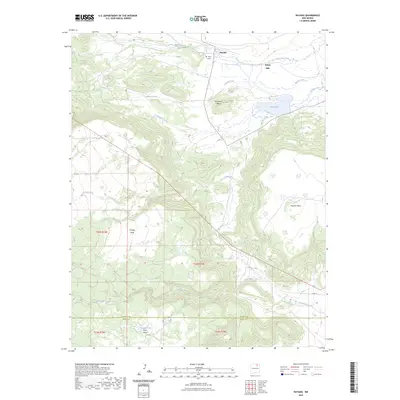
2023 Map of Rayado
USGS Topo · Published 2023About this map
Rayado stands at the northern edge of this high-altitude landscape, where the transition between the plains and the rugged mesa systems of Northern New Mexico is clearly defined. The terrain is dominated by massive flat-topped elevations including Kit Carson Mesa, Ortega Mesa, and Rayado Mesa, which dictate the drainage patterns of several waterways. Streams such as Rayado Creek and Moras Creek flow eastward from the high ground, while Miami Lake sits at the base of the mesa complex, serving as a significant catchment in this arid environment. For those tracing the human history of the area, the Abreu Cem and the settlement of Sunny Side offer tangible links to the ranching families and early inhabitants who navigated this challenging topography. The map also records the boundary line between Colfax Co and Mora Co, providing a precise look at local jurisdictional divisions in the southern reaches near Espinosa Lake.
Find a feature on this map
21 named features on this map. Tap any name to fly to it.
Don’t see what you’re looking for? This feature index may not catch every label — zoom into the map to look around manually.
Map Details
Editions of this 2023 Rayado Map
This is the sole edition of this map. No revisions or reprints were ever made.
Other maps of this area

1954 · Raton
USGS Topo · 1:250,000

1956 · Tooth Of Time
USGS Topo · 1:62,500

1956 · Miami
USGS Topo · 1:62,500

1958 · Raton
USGS Topo · 1:250,000

1966 · Mora Ranch
USGS Topo · 1:24,000

1966 · Ocate
USGS Topo · 1:24,000
1966 · Charette Lake
USGS Topo · 1:24,000

1981 · Springer
USGS Topo · 1:100,000

1983 · Taos
USGS Topo · 1:100,000
1987 · Coyote Mesa
USGS Topo · 1:24,000