
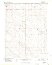
1977 Map of Raymer NE
USGS Topo · Published 1978About this map
South Pawnee Creek and North Pawnee Creek converge in this high plains landscape of northeastern Weld County during the late 1970s. The map illustrates a region defined by agricultural infrastructure and early energy development, with several Oil Wells, a Gas Well, and numerous cattle tanks dotting the township grid. Local history is anchored by the Raymer Cem and the small settlement of Igo near the creek of the same name. Family names appear on the land through features like Fiscus and Artzer, while travelers of the era would have stopped at the Pawnee Roadside Park. The presence of several Gravel Pits and a power Substa suggests a landscape transitioning toward more industrial uses while maintaining its ranching roots.
Find a feature on this map
15 named features on this map. Tap any name to fly to it.
Don’t see what you’re looking for? This feature index may not catch every label — zoom into the map to look around manually.
Map Details
Editions of this 1977 Raymer NE Map
This is the sole edition of this map. No revisions or reprints were ever made.
Other maps of this area

1954 · Sterling
USGS Topo · 1:250,000

1958 · Sterling
USGS Topo · 1:250,000
1977 · Pawnee Buttes
USGS Topo · 1:24,000
1977 · Raymer NW
USGS Topo · 1:24,000
1977 · Gatehook Spring
USGS Topo · 1:24,000

1977 · Stoneham
USGS Topo · 1:24,000
1978 · Buckingham
USGS Topo · 1:24,000

1978 · Stoneham NW
USGS Topo · 1:24,000
1978 · Avalo
USGS Topo · 1:24,000
1978 · Raymer
USGS Topo · 1:24,000