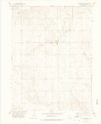
1977 Map of Gatehook Spring
USGS Topo · Published 1978About this map
Midway School stands as a central landmark in this high plains landscape of Weld County, surveyed in the mid-1970s. The map illustrates a sparse, agrarian settlement pattern where water sources like Gatehook Spring, Hightower Spring, and Razor Spring dictate the location of ranching infrastructure and remote dwellings. Drainages such as Horsetail Creek and North Pawnee Creek carve through the terrain, which is punctuated by named rises like Loaf. The presence of small settlements like Younglund and Igo near the southern edge at Igo Creek reflects the region's enduring reliance on scattered family-named outposts and seasonal watercourses. Localized industry is noted by several Well sites and a Gravel Pit, marking the intersection of natural resources and rural utility in this northern Colorado expanse.
Find a feature on this map
15 named features on this map. Tap any name to fly to it.
Don’t see what you’re looking for? This feature index may not catch every label — zoom into the map to look around manually.
Map Details
Editions of this 1977 Gatehook Spring Map
This is the sole edition of this map. No revisions or reprints were ever made.
Other maps of this area

1954 · Sterling
USGS Topo · 1:250,000

1958 · Sterling
USGS Topo · 1:250,000
1977 · Pawnee Buttes
USGS Topo · 1:24,000
1977 · Vim School
USGS Topo · 1:24,000
1977 · Raymer NW
USGS Topo · 1:24,000
1977 · Battle Canyon
USGS Topo · 1:24,000
1977 · Dolan Spring
USGS Topo · 1:24,000

1977 · Raymer NE
USGS Topo · 1:24,000

1978 · Stoneham NW
USGS Topo · 1:24,000
1978 · Avalo
USGS Topo · 1:24,000