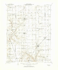
1923 Map of Raymond
USGS Topo · Published 1973About this map
Agricultural communities across Montgomery and Macoupin counties define this prairie landscape during the early 1920s. The region is anchored by the Illinois Central, Wabash, and Chicago Burlington and Quincy railroads, which facilitated the growth of towns like Farmersville, Waggoner, and Raymond. The dense distribution of rural education sites—including Lone Elm School, Star School, and Vignos School—illustrates the pre-consolidation era of local schooling.
Find a feature on this map
76 named features on this map. Tap any name to fly to it.
Don’t see what you’re looking for? This feature index may not catch every label — zoom into the map to look around manually.
Map Details
Editions of this 1923 Raymond Map
2 editions found
Other maps of this area

1912 · Gillespie
USGS Topo · 1:62,500

1915 · Gillespie
USGS Topo · 1:62,500

1915 · Mount Olive
USGS Topo · 1:62,500

1922 · Divernon
USGS Topo · 1:62,500

1923 · Carlinville
USGS Topo · 1:48,000

1923 · Taylorville
USGS Topo · 1:62,500

1923 · Raymond
USGS Topo · 1:62,500

1924 · Divernon
USGS Topo · 1:62,500

1924 · Waverly
USGS Topo · 1:62,500

1925 · Taylorville
USGS Topo · 1:62,500