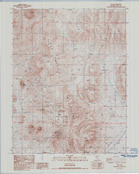
1987 Map of Rays
USGS Topo · Published 1987About this map
The San Antonio Mountains dominate this high-desert landscape in central Nevada, where 1980s infrastructure intersects with earlier mining and ranching traces. The map documents a rugged transition from high peaks like Rhyolite Peak and Red Mountain to the arid flats marked by water sources essential for survival, including Fraziers Well, Henrys Well, and the remote Slaughterhouse Spring. Mining activity is evidenced by numerous prospects and Gravel Pits scattered near the Military Reservation, while the historic Rays (Site) marks the location of a former settlement. Transportation is limited to a network of 4wd trails that cross the terrain, often following the path of utility infrastructure like the Aqueduct and high-voltage transmission lines. This survey provides a look at the mid-to-late 20th-century development of the region, where the search for minerals and the management of scarce water resources defined the human presence.
Find a feature on this map
22 named features on this map. Tap any name to fly to it.
Don’t see what you’re looking for? This feature index may not catch every label — zoom into the map to look around manually.
Map Details
Editions of this 1987 Rays Map
This is the sole edition of this map. No revisions or reprints were ever made.
Other maps of this area

1907 · Tonopah
USGS Topo · 1:250,000

1908 · Tonopah
USGS Topo · 1:250,000

1956 · Tonopah
USGS Topo · 1:250,000

1959 · Tonopah
USGS Topo · 1:250,000
1960 · Tonopah
USGS Topo · 1:24,000

1961 · Tonopah
USGS Topo · 1:62,500

1961 · Lone Mtn
USGS Topo · 1:62,500

1962 · Tonopah
USGS Topo · 1:250,000

1963 · Baxter Spring
USGS Topo · 1:62,500

1964 · San Antonio Ranch
USGS Topo · 1:62,500