
1961 Map of Tonopah
USGS Topo · Published 1962About this map
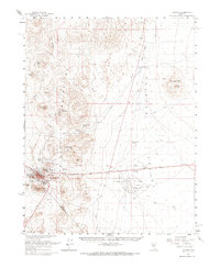
Tonopah serves as the focal point of this Nevada desert landscape, positioned at the southern terminus of the San Antonio Mountains near the border of Nye County and Esmeralda County. The map reveals an intensive history of resource extraction, with a dense cluster of claims around the townsite including the Belle of Tonopah Mine, King Tonopah Mine, and Butte Tonopah Mine. These workings are concentrated near prominent peaks such as Mt Oddie, Brougher Mtn, and Mizpah Hill, illustrating the tight connection between the town's early growth and its geological surroundings. To the east, the vast expanse of the Ralston Valley opens up, dotted with a few vital water sources like Slaughterhouse Spring and Black Rock Well. The presence of a large Military Reservation and several radio facilities highlights the mid-century transition of this high-desert region toward federal and technical infrastructure.
Find a feature on this map
41 named features on this map. Tap any name to fly to it.
Don’t see what you’re looking for? This feature index may not catch every label — zoom into the map to look around manually.
Map Details
Editions of this 1961 Tonopah Map
2 editions found
Other maps of this area

1907 · Tonopah
USGS Topo · 1:250,000

1908 · Kawich
USGS Topo · 1:250,000

1908 · Lida
USGS Topo · 1:250,000

1908 · Tonopah
USGS Topo · 1:250,000

1913 · Lida
USGS Topo · 1:250,000

1942 · Cactus Range
USGS Topo · 1:125,000

1945 · Goldfield
USGS Topo · 1:125,000

1952 · Mud Lake
USGS Topo · 1:62,500

1952 · Cactus Peak
USGS Topo · 1:62,500

1954 · Goldfield
USGS Topo · 1:250,000