
1952 Map of Mud Lake
USGS Topo · Published 1958About this map
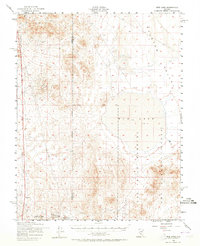
Mud Lake dominates the central landscape of this Nevada high-desert survey, sitting at the transition between the Ralston Valley and the northern reaches of the Las Vegas Bombing and Gunnery Range. The terrain reflects the region's mid-century identity, where traditional resource extraction meets the expanding military footprint of the Cold War era. Evidence of the area's earlier industrial life is found in the Dismantled Railroad and Telephone Line that trace the western edge of the quadrangle.
Find a feature on this map
18 named features on this map. Tap any name to fly to it.
Don’t see what you’re looking for? This feature index may not catch every label — zoom into the map to look around manually.
Map Details
Editions of this 1952 Mud Lake Map
2 editions found
Other maps of this area

1907 · Tonopah
USGS Topo · 1:250,000

1908 · Kawich
USGS Topo · 1:250,000

1908 · Lida
USGS Topo · 1:250,000

1908 · Tonopah
USGS Topo · 1:250,000

1913 · Lida
USGS Topo · 1:250,000

1942 · Cactus Range
USGS Topo · 1:125,000

1945 · Goldfield
USGS Topo · 1:125,000

1952 · Cactus Spring
USGS Topo · 1:62,500

1952 · Goldfield
USGS Topo · 1:62,500

1952 · Cactus Peak
USGS Topo · 1:62,500