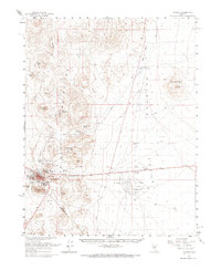
1961 Map of Tonopah
USGS Topo · Published 1968About this map
Tonopah serves as the focal point of this Nevada survey, showing the town at the intersection of the San Antonio Mountains and the wide desert floor of Ralston Valley. The landscape is dominated by the complex mining topography surrounding the settlement, with features like Mizpah Hill, Mt Oddie, and Rushton Hill highlighting the area's rich mineral history. Evidence of earlier industry is scattered throughout, from the Midway Mine in the north to the Rays (Site) to the west.
Find a feature on this map
37 named features on this map. Tap any name to fly to it.
Don’t see what you’re looking for? This feature index may not catch every label — zoom into the map to look around manually.
Map Details
Editions of this 1961 Tonopah Map
2 editions found

Other maps of this area

1907 · Tonopah
USGS Topo · 1:250,000

1908 · Kawich
USGS Topo · 1:250,000

1908 · Lida
USGS Topo · 1:250,000

1908 · Tonopah
USGS Topo · 1:250,000

1913 · Lida
USGS Topo · 1:250,000

1942 · Cactus Range
USGS Topo · 1:125,000

1945 · Goldfield
USGS Topo · 1:125,000

1952 · Mud Lake
USGS Topo · 1:62,500

1952 · Cactus Peak
USGS Topo · 1:62,500

1954 · Goldfield
USGS Topo · 1:250,000