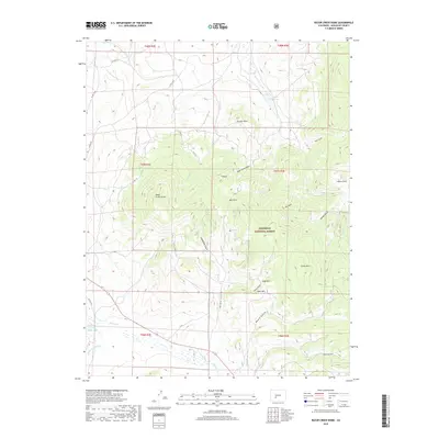
2019 Map of Razor Creek Dome
USGS Topo · Published 2019About this map
Gunnison National Forest dominates the high-elevation landscape of this Saguache County survey, where the prominent Razor Creek Dome serves as a central landmark. The terrain is defined by a complex network of named drainages and gulches, including Lightening Gulch, Dean Jones Gulch, and Wolverine Gulch, which feed into larger water systems such as Razor Cr and W Pass Cr. Hydrological management in this arid region is evidenced by the Smith Fork Ditch and the Vouga Reservoir in the northeast. The map illustrates a landscape of high-altitude parks and peaks, such as Mill Park, Sage Park, and Green Mtn. This area remains largely defined by its natural topography and resource management, with infrastructure like Co RD Uu 13 and 114 providing the primary access routes through the mountain passes and valleys.
Find a feature on this map
39 named features on this map. Tap any name to fly to it.
Don’t see what you’re looking for? This feature index may not catch every label — zoom into the map to look around manually.
Map Details
Editions of this 2019 Razor Creek Dome Map
This is the sole edition of this map. No revisions or reprints were ever made.
Other maps of this area

1956 · Montrose
USGS Topo · 1:250,000

1959 · Montrose
USGS Topo · 1:250,000

1960 · Montrose
USGS Topo · 1:250,000

1962 · Doyleville
USGS Topo · 1:24,000

1962 · West Baldy
USGS Topo · 1:24,000

1962 · Iris
USGS Topo · 1:24,000

1962 · Houston Gulch
USGS Topo · 1:24,000

1962 · Razor Creek Dome
USGS Topo · 1:24,000
1962 · Sawtooth Mountain
USGS Topo · 1:24,000
1965 · Cold Spring Park
USGS Topo · 1:24,000