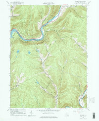
1965 Map of Readburn
USGS Topo · Published 1976About this map
The West Branch Delaware River dominates this mid-1960s landscape, illustrating the massive hydrological engineering required for New York City's water supply. Centered on the Cannonsville Reservoir, the map shows the transition of valley settlements like Rock Rift and Beerston as infrastructure shifted toward resource management. Evidence of the valley's earlier transportation era remains visible in the Old Railroad Grade and the Old Grade flanking the water. Away from the reservoir, the terrain rises sharply toward Tower Mountain and Houck Mountain, where the State Forest Preserve and landmarks like the Pines Lookout Tower define the uplands. In the southern reaches, the East Branch Delaware River passes by Centerville, while local life is anchored by sites such as the Community Full Gospel Ch and the remote settlement at Readburn.
Find a feature on this map
48 named features on this map. Tap any name to fly to it.
Don’t see what you’re looking for? This feature index may not catch every label — zoom into the map to look around manually.
Map Details
Editions of this 1965 Readburn Map
3 editions found
Other maps of this area

1920 · Long Eddy
USGS Topo · 1:62,500

1921 · Long Eddy
USGS Topo · 1:48,000

1923 · Long Eddy
USGS Topo · 1:62,500

1923 · Walton
USGS Topo · 1:48,000

1924 · Starrucca
USGS Topo · 1:48,000

1924 · Deposit
USGS Topo · 1:62,500

1925 · Walton
USGS Topo · 1:62,500

1926 · Deposit
USGS Topo · 1:62,500

1926 · Starrucca
USGS Topo · 1:62,500

1930 · Starrucca
USGS Topo · 1:48,000