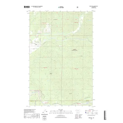
2020 Map of Reade Hill
USGS Topo · Published 2020About this map
The town of Forks and the adjacent Forks-Prairie serve as the primary human footprint in this corner of the Pacific Northwest, where the Calahaw River and its branches meet. This 2020 landscape is defined by the dense river systems of the Olympic National Forest, including the South Fork Calawah River and Elk Cr. The topography transitions from the populated valley floor to significant elevations like Reade Hill and the Olympic Mountains in the south. Notable for local history and recreation, the area includes the Forks Cem and the Pacific NW National Scenic Trail, which skirts the southern boundary. The presence of the Bogachiel Rain Forest Wetland near the Bogachiel River highlights the region's specialized ecosystem, while several named ridges like Calahaw Ridge and Elk Ridge dictate the movement of drainage creeks such as Fossil Cr and Ripple Cr.
Find a feature on this map
44 named features on this map. Tap any name to fly to it.
Don’t see what you’re looking for? This feature index may not catch every label — zoom into the map to look around manually.
Map Details
Editions of this 2020 Reade Hill Map
This is the sole edition of this map. No revisions or reprints were ever made.
Other maps of this area

1922 · Pysht
USGS Topo · 1:62,500

1935 · Lake Pleasant
USGS Topo · 1:62,500

1939 · Forks
USGS Topo · 1:62,500

1942 · Pysht
USGS Topo · 1:62,500

1942 · Lake Pleasant
USGS Topo · 1:62,500

1943 · Spruce Mountain
USGS Topo · 1:62,500

1943 · Copalis Beach
USGS Topo · 1:250,000

1951 · Copalis Beach
USGS Topo · 1:250,000

1953 · Cape Flattery
USGS Topo · 1:250,000

1956 · Spruce Mtn.
USGS Topo · 1:62,500