
1984 Map of Reading
USGS Topo · Published 1986About this map
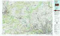
Schuylkill River winding toward the Delaware River defines the industrial and residential corridors of Southeastern Pennsylvania in the mid-1980s. This survey illustrates the dense suburbanization of the Philadelphia periphery, where major transportation arteries like the Pennsylvania Turnpike and the Northeast Extension link established manufacturing centers like Reading and Pottstown to the growing communities of Montgomery and Bucks. The map captures a high concentration of institutional landmarks, including Villanova University and Bryn Mawr College, alongside significant preservation sites such as Valley Forge National Historical Park and the Hopewell Village National Historic Site.
Find a feature on this map
152 named features on this map. Tap any name to fly to it.
Don’t see what you’re looking for? This feature index may not catch every label — zoom into the map to look around manually.
Map Details
Editions of this 1984 Reading Map
2 editions found
Other maps of this area

1888 · Mount Holly
USGS Topo · 1:62,500

1888 · Quakertown
USGS Topo · 1:62,500

1889 · Pottsville
USGS Topo · 1:62,500

1890 · Easton
USGS Topo · 1:62,500

1890 · High Bridge
USGS Topo · 1:62,500

1890 · Lambertville
USGS Topo · 1:62,500

1890 · Doylestown
USGS Topo · 1:62,500

1890 · Burlington
USGS Topo · 1:62,500

1890 · Quakertown
USGS Topo · 1:62,500

1891 · Easton
USGS Topo · 1:62,500