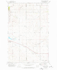
1973 Map of Reardan East
USGS Topo · Published 1977About this map
Reardan sits at the western edge of this 1970s landscape, serving as a hub for the surrounding agricultural community where the Burlington Northern railroad cuts across the plateau. The map details a transition from the wheat-growing plains of eastern Lincoln County into the basalt-coulee terrain of Spokane County. This agrarian character is emphasized by the presence of Grain Elevators, Storage Bins, and a local Landing Strip supporting farming operations.
Find a feature on this map
33 named features on this map. Tap any name to fly to it.
Don’t see what you’re looking for? This feature index may not catch every label — zoom into the map to look around manually.
Map Details
Editions of this 1973 Reardan East Map
This is the sole edition of this map. No revisions or reprints were ever made.
Other maps of this area

1943 · Medical Lake
USGS Topo · 1:62,500

1944 · Clayton
USGS Topo · 1:62,500

1944 · Wellpinit
USGS Topo · 1:62,500

1945 · Reardan
USGS Topo · 1:62,500

1950 · Clayton
USGS Topo · 1:62,500

1953 · Reardan
USGS Topo · 1:62,500

1953 · Wellpinit
USGS Topo · 1:62,500

1954 · Medical Lake
USGS Topo · 1:24,000

1954 · Medical Lake
USGS Topo · 1:62,500

1954 · Deep Creek
USGS Topo · 1:24,000