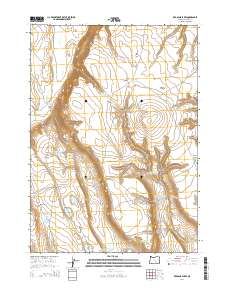
2014 Map of Red Bank Lakes
USGS Topo · Published 2014About this map
Red Bank Lakes and the surrounding high desert of Harney County are defined by an intricate network of water management features essential for ranching and wildlife in this arid landscape. This 2014 survey reveals a territory marked by numerous human-made and natural catchments, including State Game Reservoir Number Eleven and the Hidden Reservoir. The terrain is characterized by the dramatic Dry Valley Rim and the volcanic depression known as Hole in the Ground, which contains its own seasonal Hole in the Ground Lake. Practical infrastructure for land use is evident through the naming of specific stock water sources like Common Bedground Waterhole and Egan Cabin Waterhole. The map also captures local history through place names like Bacon Camp Draw and Old Jims Open, reflecting the legacy of early settlers and livestock herders who navigated this isolated corner of Oregon.
Find a feature on this map
30 named features on this map. Tap any name to fly to it.
Don’t see what you’re looking for? This feature index may not catch every label — zoom into the map to look around manually.
Map Details
Editions of this 2014 Red Bank Lakes Map
This is the sole edition of this map. No revisions or reprints were ever made.
Other maps of this area

1955 · Burns
USGS Topo · 1:250,000

1955 · Adel
USGS Topo · 1:250,000

1957 · Adel
USGS Topo · 1:250,000

1958 · Burns
USGS Topo · 1:250,000

1958 · Adel
USGS Topo · 1:250,000

1959 · Burns
USGS Topo · 1:250,000

1962 · Adel
USGS Topo · 1:250,000

1971 · Steamboat Point
USGS Topo · 1:24,000

1971 · Rock Camp Draw
USGS Topo · 1:24,000
1971 · Corporation Rim
USGS Topo · 1:24,000