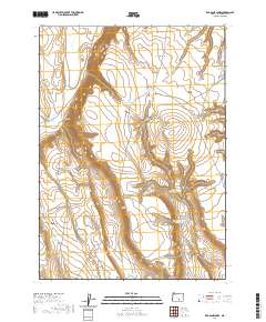
2020 Map of Red Bank Lakes
USGS Topo · Published 2020About this map
The Red Bank Lakes sit at the center of this high-desert landscape in Harney County, where water management is the primary signature on the land. The presence of numerous named waterholes and reservoirs, such as State Game Reservoir Number Eleven and the Mule Spring Road Waterhole, indicates a region heavily utilized for livestock grazing and wildlife conservation. Significant topographical landmarks like the Dry Valley Rim and Hole in the Ground define the drainage patterns that lead into the basin, while family-named features like Old Jims Lake and the Egan Cabin Waterhole point to the legacy of early ranching and homesteading efforts. The network of primitive routes, including Nasty Flat Rd and Nat For Dev Rd 6155E, provides the only access through the draws and canyons of this remote portion of eastern Oregon.
Find a feature on this map
34 named features on this map. Tap any name to fly to it.
Don’t see what you’re looking for? This feature index may not catch every label — zoom into the map to look around manually.
Map Details
Editions of this 2020 Red Bank Lakes Map
This is the sole edition of this map. No revisions or reprints were ever made.
Other maps of this area

1955 · Burns
USGS Topo · 1:250,000

1955 · Adel
USGS Topo · 1:250,000

1957 · Adel
USGS Topo · 1:250,000

1958 · Burns
USGS Topo · 1:250,000

1958 · Adel
USGS Topo · 1:250,000

1959 · Burns
USGS Topo · 1:250,000

1962 · Adel
USGS Topo · 1:250,000

1971 · Steamboat Point
USGS Topo · 1:24,000

1971 · Rock Camp Draw
USGS Topo · 1:24,000
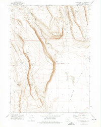
1971 · Corporation Rim
USGS Topo · 1:24,000